Big Bend is not the place for a wall
If you have stood at the mouth of Santa Elena Canyon, watched the light change on the Sierra del Carmen from Boquillas overlook, or floated the Rio Grande through Colorado Canyon, you already know why a border wall through the Big Bend is a bad idea. This is some of the most remote, rugged and beautiful country in North America, and it is also the quietest stretch of the entire U.S.-Mexico border.
Here at Terlingua Ghostown, our guests come for dark skies, open desert, and a river they can actually walk down to. A wall would put steel and floodlights across that river, cut off the views and the wildlife corridors that make this place special, and cost billions of dollars to solve a problem the numbers say Big Bend does not have. Below we look at what the Border Patrol’s own data shows, why the terrain already does most of the work, and what responsible investment, like good roads, can do for both visitors and security.
What the numbers actually say
The Big Bend Sector is the largest Border Patrol sector on the southern border and the least busy. It covers 517 miles of the Rio Grande, about a quarter of the 1,954-mile U.S.-Mexico border, across 77 Texas counties. In fiscal year 2025 it recorded 3,096 apprehensions, roughly 1.3% of the Southwest border total (Texas Tribune). Spread across 517 miles and 365 days, that is about eight apprehensions a day for the whole sector.
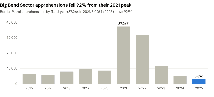
The 2021 and 2022 spike matched a border-wide surge, and Big Bend’s numbers fell faster than almost anywhere once it passed. Apprehensions dropped 74% between FY2023 and FY2025 (Fox 26 Houston), and the first seven months of FY2026 were down another 42.5% from the year before. Even DHS’s own justification for construction cites only about 89,000 apprehensions across five years, FY2021 through FY2025 (CBS News).
Big Bend had the fewest apprehensions of any Southwest border sector. Border Patrol apprehensions by sector, FY2023:
| Sector | Apprehensions | Share |
|---|---|---|
| El Paso | 427,471 | 20.9% |
| Del Rio | 393,226 | 19.2% |
| Tucson | 373,625 | 18.3% |
| Rio Grande Valley | 338,337 | 16.5% |
| San Diego | 230,941 | 11.3% |
| Yuma | 174,201 | 8.5% |
| El Centro | 50,570 | 2.5% |
| Laredo | 45,644 | 2.2% |
| Big Bend | 11,823 | 0.6% |
Compared with the other eight sectors, Big Bend is not close. In FY2023, the last full year of the surge, El Paso logged 36 times as many apprehensions and Del Rio, Big Bend’s eastern neighbor, 33 times as many. The Washington Office on Latin America notes Big Bend has ranked last among the nine sectors for most of this century (WOLA).
Inside the national park
The numbers inside Big Bend National Park are smaller still. Park figures, shared informally by Border Patrol with the National Park Service, show 130 apprehensions in 2023, 102 in 2024 and 200 in 2025 inside the park’s 118 river miles (Keep Big Bend Wild compilation). Those are calendar-year counts and are not an official CBP series, so treat them as a rough guide.
One caution on all of this: CBP publishes data by sector, not by county or by park. The sector numbers include crossings near Presidio, the Davis Mountains and points far from the park, so the Big Bend National Park share is smaller than the sector totals suggest. Border Patrol does not publish sector-level “gotaway” estimates, so we have left those out rather than guess.
The land already does the work
Along much of the Big Bend, the border is a river at the bottom of a canyon. Cliffs in Santa Elena, Mariscal and Boquillas canyons rise 500 to more than 1,000 feet straight up from the water (CBS News). Even CBP Commissioner Rodney Scott has pointed to the “unbelievably huge granite cliffs” when explaining why a 30-foot wall would not go on top of them (Texas Tribune). Beyond the river lie dozens of miles of open desert with little water and few roads, which is exactly why so few people try to cross here.
The price tag is enormous for so little return. Border security contracts in the Big Bend Sector total about $7.5 billion, roughly $14.5 million for every mile of border. In 2024, the park’s 561,000 visitors spent an estimated $56.8 million in nearby communities, supporting 585 local jobs (National Park Service). The construction budget alone equals about 130 years of that visitor spending.
The costs are not only in dollars:
- Wildlife and the river. The park lists the black-capped vireo, Mexican long-nosed bat, Big Bend gambusia, Rio Grande silvery minnow and Chisos hedgehog cactus among the species at risk. Animals like black bears, mountain lions and desert bighorn move back and forth across the river.
- Floods. The Rio Grande floods hard and fast here. Presidio officials have sued over plans to build on existing levees, warning a wall could push floodwater into town.
- History. Archaeologists warn construction could damage sites tied to Native American and Mexican families who have lived on both sides of the river for centuries.
- Laws waived. DHS waived federal environmental and historic preservation laws to speed construction in the sector, so the usual public review never happened.
That is why opposition here crosses party lines. The sheriffs of Brewster, Culberson, Hudspeth, Presidio and Terrell counties oppose a continuous wall, 46 Texas House members asked Governor Abbott to halt construction, and Texas Land Commissioner Dawn Buckingham sent a cease-and-desist letter (Texas Tribune).
Where the plans stand today
After a public outcry, CBP says it has dropped a 30-foot bollard wall inside Big Bend National Park. Plans in the park now call for about 17 miles of 4- to 6-foot vehicle barriers, detection technology, and more than 200 new or repaved patrol roads (CBS News). Outside the park, a CBP notice describes 175 miles of wall across Hudspeth, Jeff Davis and Presidio counties, and panels went up in Hudspeth County in September. CBP has changed these plans several times and says they are not final, so this is a fight worth paying attention to.
Roads done right serve visitors and security
There is a better investment than a wall, and it is one Big Bend already knows how to make: well-planned roads. The National Park Service has built roads under its own Park Road Standards for decades. Those standards say park roads “are not intended to provide fast and convenient transportation” and should be “laid lightly onto the land,” with alignments that “respect the terrain, blending into the environs” (NPS Park Road Standards).
You can see that approach every time you drive Ross Maxwell Scenic Drive or climb into the Chisos Basin. When the park rebuilt those roads in 2020 and 2021, it was a $9 million Federal Highway Administration project focused on drainage, culverts, guardrails and the expansive bentonite clay that buckles pavement here (NPS). Crews worked on posted schedules, kept every road open over Thanksgiving and the holidays, and capped delays at about 30 minutes.
Good roads built this way pay off for everyone:
- Visitors get safe access to trailheads, river put-ins, hot springs and campgrounds without the landscape being torn up to get there.
- Rangers and first responders reach a rollover, a heat emergency or a lost hiker faster, which matters in a park larger than Rhode Island.
- Border Patrol and local law enforcement get the access they actually ask for. Terrell County Sheriff Thaddeus Cleveland, a 26-year Border Patrol veteran, says he would rather have more agents, technology and access than a wall (CBS News). CBP already runs 55 autonomous surveillance towers in the sector.
What separates a responsible road from a scar is the process. Use existing corridors where possible, follow the park’s design standards, plan for flash floods and soft clay, and let the public weigh in before the bulldozers arrive. The 200-plus patrol roads now planned for the park are being pushed through under waived environmental laws, without that review. Roads for security and roads for visitors can be the same roads, if they are planned with the park instead of around it.
Keep Big Bend wild
The Big Bend Sector covers a quarter of the southern border and sees about 1% of its crossings. The canyons, the heat and the distance already make this the hardest place on the border to cross, and the people who live and work here, from ranchers to sheriffs, are telling Washington that a wall is the wrong tool. Smart roads, more agents and good technology protect both the border and the park; steel and floodlights only protect a talking point.
If you love this place, come see it, and say so. Write your members of Congress and Governor Abbott, follow the coalitions working to keep Big Bend wild, and tell your friends why the river and the canyons are worth protecting. Then come stay with us in Terlingua, watch the sun set over the Chisos, and see for yourself what is at stake.
Sources
- Texas Tribune: What to know about possible border barriers in Big Bend (Sept. 14, 2026)
- CBS News: The fight to protect one of America’s last wild places (Aug. 20, 2026)
- Keep Big Bend Wild: Big Bend Sector and BBNP migrant numbers (May 2026)
- Fox 26 Houston: 74% drop in Big Bend crossings since 2023 (Dec. 8, 2025)
- Johnston’s Archive: Border apprehensions by sector
- WOLA: U.S.-Mexico Border Update (April 2026)
- National Park Service: Tourism contributes $56.8 million (Sept. 29, 2025)
- National Park Service: Big Bend road repair project (Nov. 18, 2020)
- National Park Service: Park Road Standards (1984)
Leave a Reply